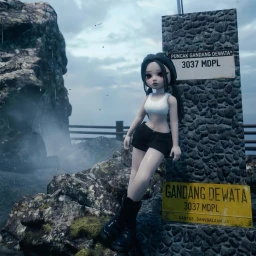
Nobody is playing MOUNT GANDANG DEWATA on Roblox right now. Its all-time peak is 36 players, reached on . It has been visited 75K times.
Performance
Profile
Concurrent players
Metrics over time
About & history
About
MOST REALISTIC MOUNT
🚧 BETA TEST - LIKE MAP FOR SUPPORT🚧
Designated as the 53rd National Park, this area is known for its extreme hiking trails and enchanting moss forests. It is the highest mountain in West Sulawesi Province, with an elevation of around 3,037 to 3,074 meters above sea level, located in Mamasa Regency, in the Quarlesi Mountains.
Change history
Name historynone yet
No changes recorded since tracking began.
Genre historynone yet
No changes recorded since tracking began.
Description history4 changes
MOST REALISTIC MOUNT
🚧 BETA TEST – LIKE MAP FOR SUPPORT🚧
Designated as the 53rd National Park, this area is known for its extreme hiking trails and enchanting moss forests. It is the highest mountain in West Sulawesi Province, with an elevation of around 3,037 to 3,074 meters above sea level, located in Mamasa Regency, in the Quarlesi Mountains.
→MOST REALISTIC MOUNT
🚧 BETA TEST - LIKE MAP FOR SUPPORT🚧
Designated as the 53rd National Park, this area is known for its extreme hiking trails and enchanting moss forests. It is the highest mountain in West Sulawesi Province, with an elevation of around 3,037 to 3,074 meters above sea level, located in Mamasa Regency, in the Quarlesi Mountains.
MOST REALISTIC MOUNT
🚧 BETA TEST - LIKE MAP FOR SUPPORT🚧
Designated as the 53rd National Park, this area is known for its extreme hiking trails and enchanting moss forests. It is the highest mountain in West Sulawesi Province, with an elevation of around 3,037 to 3,074 meters above sea level, located in Mamasa Regency, in the Quarlesi Mountains.
→MOST REALISTIC MOUNT
🚧 BETA TEST – LIKE MAP FOR SUPPORT🚧
Designated as the 53rd National Park, this area is known for its extreme hiking trails and enchanting moss forests. It is the highest mountain in West Sulawesi Province, with an elevation of around 3,037 to 3,074 meters above sea level, located in Mamasa Regency, in the Quarlesi Mountains.
MOST REALISTIC MOUNT
🚧 BETA TEST – LIKE MAP FOR SUPPORT🚧
Designated as the 53rd National Park, this area is known for its extreme hiking trails and enchanting moss forests. It is the highest mountain in West Sulawesi Province, with an elevation of around 3,037 to 3,074 meters above sea level, located in Mamasa Regency, in the Quarlesi Mountains.
→MOST REALISTIC MOUNT
🚧 BETA TEST - LIKE MAP FOR SUPPORT🚧
Designated as the 53rd National Park, this area is known for its extreme hiking trails and enchanting moss forests. It is the highest mountain in West Sulawesi Province, with an elevation of around 3,037 to 3,074 meters above sea level, located in Mamasa Regency, in the Quarlesi Mountains.
MOST REALISTIC MOUNT
🚧 BETA TEST - LIKE MAP FOR SUPPORT🚧
Designated as the 53rd National Park, this area is known for its extreme hiking trails and enchanting moss forests. It is the highest mountain in West Sulawesi Province, with an elevation of around 3,037 to 3,074 meters above sea level, located in Mamasa Regency, in the Quarlesi Mountains.
→MOST REALISTIC MOUNT
🚧 BETA TEST – LIKE MAP FOR SUPPORT🚧
Designated as the 53rd National Park, this area is known for its extreme hiking trails and enchanting moss forests. It is the highest mountain in West Sulawesi Province, with an elevation of around 3,037 to 3,074 meters above sea level, located in Mamasa Regency, in the Quarlesi Mountains.
Icon historynone yet
No changes recorded since tracking began.
Thumbnail historynone yet
No changes recorded since tracking began.
Video historynone yet
No changes recorded since tracking began.
Related games
Ranked just above and below it in Adventure, by players right now.